


This episode of the Thinking Spatially podcast discusses the geographic implications of observatories from ancient times to our modern times.
Podcast
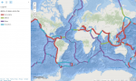
Magellan: Launching Global Exploration
This podcast focuses on Ferdinand Magellan (1480-1521) and the impact his 1519-1521 voyage had on geography, cartography, exploration, and much more, during its time and down to our present age.
Proximity and Adjacency: Why they matter, and how to teach them through mathematics, maps, and geography
This episode of the Thinking Spatially Podcast focuses on the concepts of Proximity and Adjacency: Why they matter, and how to teach them through mathematics, maps, and geography.
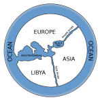
Political Boundaries along Lines of Latitude and Longitude
The podcast Political Boundaries along lines of latitude and longitude explores the geographic implications of the history and development of political boundaries, why they matter, and which political boundaries are […]
Northwest Ordinance Act: Surveying and Settling the Land
This episode of the Thinking Spatially podcast examines how the Northwest Ordinance Act in the USA impacted surveying and settling of the land, geographic thought, and geotechnologies.
The Earths Magnetic Field: Impacting Geography from the Ground Up
This episode of the Thinking Spatially podcast explores how the investigation and discovery of the Earth’s magnetic field influenced geography and our everyday lives.
Columbus: Permanently Altering Global Relationships
This episode of the Thinking Spatially podcast focuses on the controversial figure of Columbus and how his exploration and voyages permanently Altered Global Relationships to the present day.
The French Geodesic Mission: 1 degree of Latitude
This episode of the Thinking Spatially podcast examines the French Geodesic Mission of 1730 and its impact on our understanding of the Earth, including elements of geotechnologies, political geography, and […]
Lewis and Clark: Researching, Mapping, and Exploring to the Coast
This episode of the Thinking Spatially podcast focuses on the impact that Lewis and Clark had on geographic tools, geographic thinking, settlement patterns, the relationship to Native Americans, and more, […]
The Earth in Space: Seeing the World as it Truly Is
This episode of the Thinking Spatially podcast focuses on how space exploration helped us understand our own Earth and how it influenced geographic thinking.
Brunel: Modifying the Landscape in the Industrial Revolution
This episode of the Thinking Spatially podcast focuses on Brunel and how his work led to the modification of the Landscape in the Industrial Revolution and to the present day.
Aryabhata and Brahmagupta: Using Mathematics to Explain Geography
This episode in the Thinking Spatially podcast series focuses on Indian mathematicians Aryabhata and Brahmagupta: How their advancements in Mathematics greatly aided the discipline of Geography and geographic technology.
The Environmental Movement: Connecting Geography to a Higher Purpose
This episode in the Thinking Spatially podcast series discusses the environmental movement: How it began, what it is, and its impact on geographic thinking.
Teaching GeoEthics
This episode of the Thinking Spatially podcast series describes why ethics is central to work in geography and mapping, and discusses strategies on how and why to teach geo-ethics.
Antarctica: To the End of Earth
Antarctica: To the End of Earth: This podcast describes the exploration of Antarctica and its impact on science and on geographic thinking.
Al Biruni: Laying the Geodetic Foundations
This episode describes the life and discoveries of Al-Biruni, who laid the geodetic foundations for what we understand about the Earth.
 Spatial Citizenship Education: What it is and why it matters
Join me for a chat about: Spatial Citizenship Education: What it is and why it matters.
 Marco Polo: From West to East and Back Again
Join me as we discuss the life, exploration, and impact that Marco Polo’s journey from Italy to China and back again had.
 What are the 10 most important educational benefits to GIS?
Join me as we discuss the 10 most important educational benefits that GIS (Geographic Information Systems) offers.
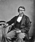 David Livingstone: A European with a Heart for Africa
Join me as we discuss the life and impact of David Livingstone of the 19th Century: A European with a heart for Africa.
 What is GIS and why teach with it?
Join me as we discuss what is Geographic Information Systems (GIS), and why teach with this important framework, data sets, and tools?
Pliny the Elder: Creating the First Encyclopedia of Geography
Join me as we discuss the amazing feat of Pliny the Elder’s encyclopedia, his life, his spectacular death, and the impact his work had.
What are the 10 key strategies for teaching GIS?
Join me as we discuss the 10 key strategies for teaching GIS–Geographic Information Systems. Many choices exist, and this chat will help you navigate those choices and make informed ones.
Aerial Photography: Examining the Earth from Above
Aerial Photography: Examining the Earth from Above. Think spatially as we examine the development and influence that aerial photography has had since the mid 19th Century, and its impact on […]
On becoming a GISP GIS Professional
My story of becoming a GISP – a GIS professional as certified by the GIS Certification Institute, and why you should consider becoming one as well.
George Perkins Marsh: Humans as Change Agents
Join me as we chat about George Perkins Marsh, who pioneered the concept of humans as change agents: His life and legacy, and why it all matters.
What are the 10 most important GIS skills in education?
Let’s chat about the 10 most important GIS (Geographic Information Systems) skills to focus on and foster in education. I contend that if you and your students gain confidence in […]
Leif Eriksson: Visiting North America in 1001
Lets chat about Leif Eriksson’s life, voyages to North America and elsewhere, and the impact it all had on exploration, history, and geography.
 Copernicus: Establishing correct Earth-Sun Relationships
Copernicus: Establishing correct Earth-Sun Relationships. Think spatially as we examine Copernicus’ life and impact, and why it matters on down to today.
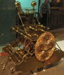
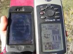
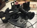 Cross-staffs, astrolabes, and other devices: Determining Positions on the Planet
Cross-staffs, astrolabes, and other devices: Determining Positions on the Planet, and paving the way for GPS. Think spatially as we consider these devices, how they were used, and the impact […]
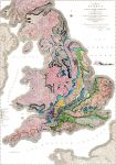 Smith: Breaking New Ground with Stratigraphy
Smith: Breaking New Ground with Stratigraphy: Think spatially on the life and impact of William Smith, creator of the world’s first modern geologic map.
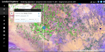 10 Useful and Amazing Web Mapping Applications
Think spatially as we examine 10 amazing web mapping applications that I have used in a wide variety of research and teaching settings, and you can do the same, including […]
 Harrison: Solving the Longitude Problem
Harrison: Solving the Longitude Problem: Think spatially as we examine how the hard work, tenacity, and innovations of John Harrison’s longitude clock transformed the world and our understanding of it.
 National Mapping Agencies: Mapping the Nations
National Mapping Agencies: Mapping the Nations: Think spatially as you consider the history and mission of national mapping agencies around the world, and the impact they had and continue to […]
 Zheng He: Sailing from East to West
Zheng He: Sailing from East to West: Think spatially as you consider the life and voyages of Zheng He of China and the impact they made.
 Wegener: On Solid Ground? Not so much.
Think spatially as we examine the life, theories, and challenges faced by Alfred Wegener, and his influence through plate tectonics on how we understand our planet.
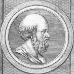 Eratosthenes: Calculating the Earth’s Circumference
Eratosthenes: Calculating the Earth’s Circumference: Think spatially as we examine the work and influence that Eratosthenes had on our understanding of the planet’s size, and much more.
 Burnham: Make no Small Plans
Think spatially as we examine the life and influence of architect Daniel Burnham, and the impact his ideas had on buildings and cities.
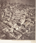 Aerial Photography: Examining the Earth from Above
Aerial Photography: Examining the Earth from Above. Think spatially as we examine the development and influence that aerial photography has had since the mid 19th Century, and its impact on […]
Geoliteracy: What it is, Why it Matters, and where it needs to be taught
Think spatially as we examine geoliteracy: What it is, why it matters, and where it needs to be taught.
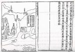
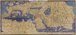 Al-Idrisi: Pleasant Journeys into Faraway Lands and the amazing Silver Map
Discover the amazing map of silver and the extensive exploration and writing of cartographer al-Idrisi (c. 1099-1166).
 Bridges and Tunnels: Connecting Spaces, Joining Places
Discover how thousands of years of building bridges and tunnels did not simply join opposite shores or sides of mountains, but united regions politically and economically, and even culturally.
 Anaximander: The First Map of the World
Learn why Anaximander’s first map of the world was so revolutionary, and how this Greek philosopher’s thinking shaped our modern conception of the Earth and of space.
 Applied Geography: Solving the World’s Problems
Learn how geographic thinking and geographic technology are addressing the world’s most complex problems from local to global scale, including those in health, transportation, agriculture, energy, and many more fields.
 Ibn Battuta and his Rihla: The Wonders of Traveling
Hear all about the amazing journeys and tales from Ibn Battuta, 14th Century world traveler.
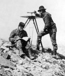
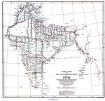 The Great Trigonometric Survey of India: Cartography, Fieldwork, and Politics
Hear all about The Great Trigonometric Survey of India, and its implications for cartography, fieldwork, and political geography.
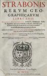 Strabo’s Geographica: The Whole Known World
In today’s blog and Twitter-saturated world of short text, Strabo’s (63 BCE – c. 24 CE) Geographica seems almost from another world. Not only was it lengthy—composed of 17 books—but […]
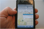 Webmapping: Maps anywhere, anytime, on any device
Entering an address into your smartphone, a web browser, or in an in-vehicle GPS device and getting turn-by-turn directions, a photograph at each turn, and a map or satellite image […]
 Latitude and Longitude: Addresses for the Planet
Join geographer Joseph Kerski as we discuss what latitude and longitude are, its history, and how their development helped usher in a modern global society.
 National Statistical Agencies: Counting the Population, and much more.
Join Joseph Kerski as we, in this Decennial Census year of 2020 in the USA, discuss the history and development of national statistical agencies, their roles, and how they have […]
 Supply Chain Management: Transforming the World
What is supply chain management? What are geography’s contributions to and the geographic implications of modern supply chain management?
 Thinking Spatially Podcast: Geography is Revolutionary
This new episode in the Thinking Spatially podcast invites you to consider why geography is revolutionary. From Zheng He’s voyages from China in the 1400s to the UAVs and Drones […]
 Citizen Science: Ordinary People, Extraordinary Consequences
Explore the modern phenomena of citizen science, with historical roots back to the 19th Century, and its geographic implications, narrated by geographer Joseph Kerski. Citizen science–the gathering of scientific data […]
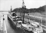 Canals: Building the Future, Impacting World Geography
Canals, past and present, impacted regional and world physical geography on a local but also global scale. Explore how canals influenced geography, and how geography influenced canals, narrated by Geographer […]
Al Idrisi: Map of Silver, Cartographer, Geographer
Explore the incredible map of silver, and the amazing life and work of Al-Idrisi (c. 1099-1166 CE) as narrated by geographer Joseph Kerski. Be inspired and amazed at the meticulous […]
 Air Travel: Compressing Distance, Altering Geography
Air travel has perhaps altered our planet more than any other single thing–compressing distance, enabling global tourism, sports, and travel, enabling supply chains, and much more. With geographer Joseph Kerski, […]
 The World Has No Problems – Not – Hence GIS
Everything is great in our world, right? Not! Our world faces significant challenges, from water quality and quantity, to weather and climate, natural hazards, energy, human health, economic inequalities, urban […]
 Why Get Excited About Web Maps
Why are maps generated with modern geotechnologies different from maps of the past? Join Geographer Joseph Kerski as we examine the paradigm shift that web mapping tools and data have […]
 Why GIS in Education Matters
Why does Geographic Information Systems (GIS) in education bring value to teaching, learning, research, and administration? Join Geographer Joseph Kerski as we explore some of the reasons why educators from […]
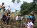
 The Importance of Outdoor Education
Why is outdoor education so neglected and yet so important in 21st Century teaching and learning? Outdoor education fosters community connection, teamwork, environmental sensitivity, sense of place, and problem-based learning. […]
 Make Every Day GIS Day
The 2018 GIS (geographic information systems) Day is Wednesday 14 November 2018. GIS Day has been celebrated every year since 1999 as a way for organizations to showcase the things […]