


AP Human Geography: Teaching with GeoTechnologies
This 12-step pathway will help you enrich your AP Human Geography (APHG) instruction with dynamic and rich web maps made with Geotechnologies (which include Geographic Information Systems, Remote Sensing, Global Positioning Systems (GPS), and web mapping). When you have completed this pathway, you will:
(1) Understand what Geographic Information Systems (GIS) is and how it is used in society.
(2) Understand how and why GIS can be used in teaching AP Human Geography (APHG).
(3) Know how to use web-based GIS (ArcGIS Online) to examine spatial relationships, online maps, and to create your own maps from local to global scales that support the 7 themes of APHG.
(4) Understand where to go for further exploration in the educational application of geotechnologies.
-
1
 Learn about what GIS is and its connections to geography
DO:
Watch the video: http://www.youtube.com/watch?v=UkY4Omuoho0
REFLECT:
How is GIS different from using paper maps or atlases? How is it similar?

-
2
 Look at different fields in which GIS is used
DO:
Skim the Esri industries page: http://www.esri.com/industries
REFLECT:
Why is GIS used in so many fields? Why is the “where” question so important?
-
3
 Look at different maps that GIS users have made
DO:
Examine some maps here: http://media.esri.com/mapbook/volume27/index.html
REFLECT:
Why is GIS used in so many fields? Why is the “where” question so important?
-
4
 Watch how GIS used in different careers
DO:
Watch 1 career video of your choice: http://edcommunity.esri.com/Careers/career-videos
REFLECT:
How does the person in your chosen video use GIS on the job?
-
5
 Learn why GIS is used in education
DO:
Watch presentation “Why GIS in education matters”: http://www.arcgis.com/home/webmap/presentation.html?webmap=6e06d858c1ea4888859c03494c9df6ad
REFLECT:
What are 5 reasons why educators are attracted to the use of GIS in education? This presentation uses the ArcGIS Online platform! Think about using this platform for student presentations.
-
6
 Learn how GIS can be used in education
DO:
Examine a few case studies on http://edcommunity.esri.com/Resources/case-studies
REFLECT:
What are some things that educators are doing with GIS? Why are educators using GIS?
-
7
 Learn how GIS connects with the 7 Themes of APHG
DO:
Skim “Connecting GIS to APHG”: http://edcommunity.esri.com/~/media/Files/EdCommunity/Lesson%20Files/g/Connecting_GIS_to_AP_Human_Geography.pdf
REFLECT:
What are 3 linkages between GIS and APHG? Why are you interested in using GIS in APHG? How can you use field work in conjunction with GIS?
-
8
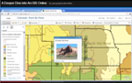
 Use Web GIS to Examine APHG Theme VI: Industrialization and Economic Development
DO:
Open a web GIS Map: Theme V: Agriculture and Food Production, and Rural Land Use, and Theme VII: Cities and Urban Land Use http://changematters.esri.com/compare
- Search for “Aral Sea”
- Search for “qaryat al ulya, Saudi Arabia” (zoom out a bit)
REFLECT:
- Observe changes in the Aral Sea over time and discuss reasons for those changes.
- Observe changes in center pivot irrigation over time and discuss reasons.
Where else on Earth would you like to examine? How could you use this resource in your own instruction?
-
9
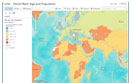 Use Web GIS to Examine APHG Theme II: Population and Migration
DO:
Examine the relationship of age, population growth, and life expectancy, and how those variables have changed over time, with World Bank data in ArcGIS Online:
http://www.arcgis.com/home/webmap/viewer.html?webmap=64cc54ed97354a05b5de14362c5d4b8c
REFLECT:
How has Zambia’s life expectancy changed over time compared to that of Saudi
Arabia’s?What is the relationship between age, population growth, and life expectancy?
How could you use this resource in your own instruction?
-
10
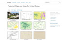 Explore the Gallery of ArcGIS Online Maps
DO:
Explore the gallery of ArcGIS Online maps:
http://www.arcgis.com/home/gallery.html
REFLECT:
What sort of maps could you make as you teach APHG? What maps could your students make to investigate APHG topics?
-
11
 Create your own web GIS Map with multimedia
DO:
- Watch this video to discover how to Add Map Notes with photographs and videos: http://www.youtube.com/watch?v=XHRJYYEE3Gs&list=PLiC1i3ejK5vtyUTMRDSZYcSZwJ12E2VCN
- Then, make your own map on a topic of interest to you. If you wish to save it, create a free public
account on https://www.arcgis.com/home/signin.html
REFLECT:
What topic is of interest to you?
-
12
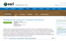 Take a Short Course in Teaching with GIS
DO:
Take the course “Teaching with GIS” on http://esriurl.com/vcteachingwithgis
REFLECT:
How can you use these techniques in your APHG course?
What is your next step in using GIS in APHG?