


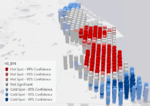
My workshops and presentations at the 2024 AAG Geography Annual Meeting. I hope these resources are very helpful to you during and also, long after the conference! Esri exhibit: WED […]
Welcome to my website
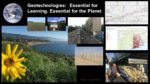
Teaching with Geotechnologies (Geographic Information Systems (GIS), Global Positioning Systems (GPS), Virtual Globes, and Remote Sensing not only can engage the learner in inquiry-driven, problem-based, project-based investigations of real-world issues, but it is essential for 21st Century sustainability of the planet and the health of its people. If we do not foster spatial thinking about issues such as water quality and availability, energy, sustainable agriculture, land use, urban sprawl, biodiversity loss, human health, natural hazards, and soil erosion, population and migration, at scales from local to global, who will?
“Now more than ever, we need people who think broadly and who understand systems, connections, patterns, and root causes … how to think in whole systems, how to find connections, how to ask big questions, and how to separate the trivial from the important.” –David Orr, Earth In Mind: On Education, Environment, and the Human Prospect, 1994.
Latest Posts
Observatories: Monitors of the Earth and Beyond
This episode of the Thinking Spatially podcast discusses the geographic implications of observatories from ancient times to our modern times.
Magellan: Launching Global Exploration
This podcast focuses on Ferdinand Magellan (1480-1521) and the impact his 1519-1521 voyage had on geography, cartography, exploration, and much more, during its time and down to our present age.
Supporting and Promoting GIS in Education with colleagues in Malaysia and Japan
Why “Where” Matters to Education: Malaysia Mengapa di mana Penting Dalam Pendidikan: Schools and higher education: Instruction, research, and campus facilities https://storymaps.arcgis.com/stories/acb0d18062294d3bab78394a35d12f4a Why “Where” Matters to Education: Japan Women’s University […]
Proximity and Adjacency: Why they matter, and how to teach them through mathematics, maps, and geography
This episode of the Thinking Spatially Podcast focuses on the concepts of Proximity and Adjacency: Why they matter, and how to teach them through mathematics, maps, and geography.
New Mexico Workshops on GIS, Education, Mathematics, and Society
New Mexico Workshops and Presentations This series of workshops and presentations were created with the goal of empowering students, faculty, and others in education in multiple disciplines and levels with […]
Political Boundaries along Lines of Latitude and Longitude
The podcast Political Boundaries along lines of latitude and longitude explores the geographic implications of the history and development of political boundaries, why they matter, and which political boundaries are […]
2023 Recap and Gratitude: Joseph Kerski
Greetings! Joseph Kerski here with you. It has been an incredible honor partnering with you all in the GIS education space; I had a wonderfully spatial and fulfilling year and […]
Northwest Ordinance Act: Surveying and Settling the Land
This episode of the Thinking Spatially podcast examines how the Northwest Ordinance Act in the USA impacted surveying and settling of the land, geographic thought, and geotechnologies.
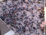
Presentations in New York for GIS Day
Monroe Community College microcredential innovation: https://www.esri.com/about/newsroom/arcuser/microcredential-program-ensures-workplace-success/ Teaching Equity with GIS: https://storymaps.arcgis.com/stories/6b575e79dc0c427585d5512e96a82b3f Strategies for finding geospatial data: https://spatialreserves.wordpress.com/2020/09/21/strategies-for-finding-geospatial-data/ Modern strategies for finding geospatial data Teaching and Learning Ethics with spatial thinking and […]
The Earths Magnetic Field: Impacting Geography from the Ground Up
This episode of the Thinking Spatially podcast explores how the investigation and discovery of the Earth’s magnetic field influenced geography and our everyday lives.
Teaching and Research with the Business Analyst Web App
Business Analyst Web App workshop is content that explains what the app is and how it can be used in research and instruction.
Columbus: Permanently Altering Global Relationships
This episode of the Thinking Spatially podcast focuses on the controversial figure of Columbus and how his exploration and voyages permanently Altered Global Relationships to the present day.
The French Geodesic Mission: 1 degree of Latitude
This episode of the Thinking Spatially podcast examines the French Geodesic Mission of 1730 and its impact on our understanding of the Earth, including elements of geotechnologies, political geography, and […]
Cartographic Design Syllabus
Cartographic Design course syllabus Syllabus for my cartographic design full semester online course.
AGIC Arizona GIS Conference Keynote and Workshop content
The content for my keynote at the Arizona GIS Conference (AGIC) is here. kerski_connectingfield The content for my workshop on connecting Survey123, maps, dashboards, and story maps is here as […]
Workshop on Comparing Field Apps
Comparing Field Tools Presentation, guidelines, and links.
Lewis and Clark: Researching, Mapping, and Exploring to the Coast
This episode of the Thinking Spatially podcast focuses on the impact that Lewis and Clark had on geographic tools, geographic thinking, settlement patterns, the relationship to Native Americans, and more, […]
The Earth in Space: Seeing the World as it Truly Is
This episode of the Thinking Spatially podcast focuses on how space exploration helped us understand our own Earth and how it influenced geographic thinking.
Brunel: Modifying the Landscape in the Industrial Revolution
This episode of the Thinking Spatially podcast focuses on Brunel and how his work led to the modification of the Landscape in the Industrial Revolution and to the present day.
Aryabhata and Brahmagupta: Using Mathematics to Explain Geography
This episode in the Thinking Spatially podcast series focuses on Indian mathematicians Aryabhata and Brahmagupta: How their advancements in Mathematics greatly aided the discipline of Geography and geographic technology.
The Environmental Movement: Connecting Geography to a Higher Purpose
This episode in the Thinking Spatially podcast series discusses the environmental movement: How it began, what it is, and its impact on geographic thinking.
Teaching GeoEthics
This episode of the Thinking Spatially podcast series describes why ethics is central to work in geography and mapping, and discusses strategies on how and why to teach geo-ethics.
Antarctica: To the End of Earth
Antarctica: To the End of Earth: This podcast describes the exploration of Antarctica and its impact on science and on geographic thinking.
Al Biruni: Laying the Geodetic Foundations
This episode describes the life and discoveries of Al-Biruni, who laid the geodetic foundations for what we understand about the Earth.
 Spatial Citizenship Education: What it is and why it matters
Join me for a chat about: Spatial Citizenship Education: What it is and why it matters.
 Marco Polo: From West to East and Back Again
Join me as we discuss the life, exploration, and impact that Marco Polo’s journey from Italy to China and back again had.
 What are the 10 most important educational benefits to GIS?
Join me as we discuss the 10 most important educational benefits that GIS (Geographic Information Systems) offers.
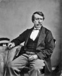 David Livingstone: A European with a Heart for Africa
Join me as we discuss the life and impact of David Livingstone of the 19th Century: A European with a heart for Africa.
 What is GIS and why teach with it?
Join me as we discuss what is Geographic Information Systems (GIS), and why teach with this important framework, data sets, and tools?
Pliny the Elder: Creating the First Encyclopedia of Geography
Join me as we discuss the amazing feat of Pliny the Elder’s encyclopedia, his life, his spectacular death, and the impact his work had.
What are the 10 key strategies for teaching GIS?
Join me as we discuss the 10 key strategies for teaching GIS–Geographic Information Systems. Many choices exist, and this chat will help you navigate those choices and make informed ones.
Aerial Photography: Examining the Earth from Above
Aerial Photography: Examining the Earth from Above. Think spatially as we examine the development and influence that aerial photography has had since the mid 19th Century, and its impact on […]
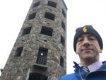
Photos of Joseph Kerski for use in upcoming presentations, media, and other events and publications
Sketch 1. Sketch 2. Abbey Road. Giving TED Talk. Black background. Presenting. Fieldwork text at Indiana Dunes. At […]
Connecting Field Surveys, Maps, Dashboards, and Story Maps: A Workshop
Connecting Field Surveys, Maps, Dashboards, and Story Maps: A Workshop. Here is the final result: https://community.esri.com/t5/education-blog/how-walkable-is-your-community/ba-p/883382 Here are my slides: field_data_collecting_mapping_analyzing_communicating_jjk
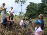
Creating Positive Change: The use of GIS in Native Education
Creating Positive Change: The use of GIS in Native Education: Story map and PDF: Tribal_lands_conf_Creating Positive Change_ The use of GIS in Native Education.
On becoming a GISP GIS Professional
My story of becoming a GISP – a GIS professional as certified by the GIS Certification Institute, and why you should consider becoming one as well.
George Perkins Marsh: Humans as Change Agents
Join me as we chat about George Perkins Marsh, who pioneered the concept of humans as change agents: His life and legacy, and why it all matters.
What are the 10 most important GIS skills in education?
Let’s chat about the 10 most important GIS (Geographic Information Systems) skills to focus on and foster in education. I contend that if you and your students gain confidence in […]
Leif Eriksson: Visiting North America in 1001
Lets chat about Leif Eriksson’s life, voyages to North America and elsewhere, and the impact it all had on exploration, history, and geography.
 Copernicus: Establishing correct Earth-Sun Relationships
Copernicus: Establishing correct Earth-Sun Relationships. Think spatially as we examine Copernicus’ life and impact, and why it matters on down to today.
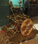
 Cross-staffs, astrolabes, and other devices: Determining Positions on the Planet
Cross-staffs, astrolabes, and other devices: Determining Positions on the Planet, and paving the way for GPS. Think spatially as we consider these devices, how they were used, and the impact […]
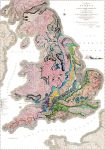 Smith: Breaking New Ground with Stratigraphy
Smith: Breaking New Ground with Stratigraphy: Think spatially on the life and impact of William Smith, creator of the world’s first modern geologic map.
 10 Useful and Amazing Web Mapping Applications
Think spatially as we examine 10 amazing web mapping applications that I have used in a wide variety of research and teaching settings, and you can do the same, including […]
 Harrison: Solving the Longitude Problem
Harrison: Solving the Longitude Problem: Think spatially as we examine how the hard work, tenacity, and innovations of John Harrison’s longitude clock transformed the world and our understanding of it.
 National Mapping Agencies: Mapping the Nations
National Mapping Agencies: Mapping the Nations: Think spatially as you consider the history and mission of national mapping agencies around the world, and the impact they had and continue to […]
 Zheng He: Sailing from East to West
Zheng He: Sailing from East to West: Think spatially as you consider the life and voyages of Zheng He of China and the impact they made.
 Wegener: On Solid Ground? Not so much.
Think spatially as we examine the life, theories, and challenges faced by Alfred Wegener, and his influence through plate tectonics on how we understand our planet.
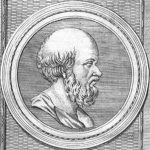 Eratosthenes: Calculating the Earth’s Circumference
Eratosthenes: Calculating the Earth’s Circumference: Think spatially as we examine the work and influence that Eratosthenes had on our understanding of the planet’s size, and much more.
 Burnham: Make no Small Plans
Think spatially as we examine the life and influence of architect Daniel Burnham, and the impact his ideas had on buildings and cities.
Joseph Kerski in Mojave Desert
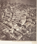 Aerial Photography: Examining the Earth from Above
Aerial Photography: Examining the Earth from Above. Think spatially as we examine the development and influence that aerial photography has had since the mid 19th Century, and its impact on […]
Geoliteracy: What it is, Why it Matters, and where it needs to be taught
Think spatially as we examine geoliteracy: What it is, why it matters, and where it needs to be taught.
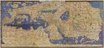 Al-Idrisi: Pleasant Journeys into Faraway Lands and the amazing Silver Map
Discover the amazing map of silver and the extensive exploration and writing of cartographer al-Idrisi (c. 1099-1166).
 Bridges and Tunnels: Connecting Spaces, Joining Places
Discover how thousands of years of building bridges and tunnels did not simply join opposite shores or sides of mountains, but united regions politically and economically, and even culturally.
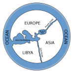 Anaximander: The First Map of the World
Learn why Anaximander’s first map of the world was so revolutionary, and how this Greek philosopher’s thinking shaped our modern conception of the Earth and of space.
 Applied Geography: Solving the World’s Problems
Learn how geographic thinking and geographic technology are addressing the world’s most complex problems from local to global scale, including those in health, transportation, agriculture, energy, and many more fields.
 Ibn Battuta and his Rihla: The Wonders of Traveling
Hear all about the amazing journeys and tales from Ibn Battuta, 14th Century world traveler.
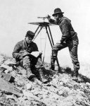
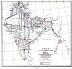 The Great Trigonometric Survey of India: Cartography, Fieldwork, and Politics
Hear all about The Great Trigonometric Survey of India, and its implications for cartography, fieldwork, and political geography.
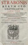 Strabo’s Geographica: The Whole Known World
In today’s blog and Twitter-saturated world of short text, Strabo’s (63 BCE – c. 24 CE) Geographica seems almost from another world. Not only was it lengthy—composed of 17 books—but […]
 Webmapping: Maps anywhere, anytime, on any device
Entering an address into your smartphone, a web browser, or in an in-vehicle GPS device and getting turn-by-turn directions, a photograph at each turn, and a map or satellite image […]
 Latitude and Longitude: Addresses for the Planet
Join geographer Joseph Kerski as we discuss what latitude and longitude are, its history, and how their development helped usher in a modern global society.
 National Statistical Agencies: Counting the Population, and much more.
Join Joseph Kerski as we, in this Decennial Census year of 2020 in the USA, discuss the history and development of national statistical agencies, their roles, and how they have […]
 Supply Chain Management: Transforming the World
What is supply chain management? What are geography’s contributions to and the geographic implications of modern supply chain management?
 Thinking Spatially Podcast: Geography is Revolutionary
This new episode in the Thinking Spatially podcast invites you to consider why geography is revolutionary. From Zheng He’s voyages from China in the 1400s to the UAVs and Drones […]
 Citizen Science: Ordinary People, Extraordinary Consequences
Explore the modern phenomena of citizen science, with historical roots back to the 19th Century, and its geographic implications, narrated by geographer Joseph Kerski. Citizen science–the gathering of scientific data […]
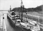 Canals: Building the Future, Impacting World Geography
Canals, past and present, impacted regional and world physical geography on a local but also global scale. Explore how canals influenced geography, and how geography influenced canals, narrated by Geographer […]
Al Idrisi: Map of Silver, Cartographer, Geographer
Explore the incredible map of silver, and the amazing life and work of Al-Idrisi (c. 1099-1166 CE) as narrated by geographer Joseph Kerski. Be inspired and amazed at the meticulous […]
 Air Travel: Compressing Distance, Altering Geography
Air travel has perhaps altered our planet more than any other single thing–compressing distance, enabling global tourism, sports, and travel, enabling supply chains, and much more. With geographer Joseph Kerski, […]
Announcing new book: Spatial Thinking in Environmental Contexts: Maps, Archives, and Timelines
Announcing my newest book:Spatial Thinking in Environmental Contexts: Maps, Archives, and Timelines, published by CRC Press, 2019. This book cultivates the spatial thinking “habit of mind” as a critical geographical view […]
 The World Has No Problems – Not – Hence GIS
Everything is great in our world, right? Not! Our world faces significant challenges, from water quality and quantity, to weather and climate, natural hazards, energy, human health, economic inequalities, urban […]
 Why Get Excited About Web Maps
Why are maps generated with modern geotechnologies different from maps of the past? Join Geographer Joseph Kerski as we examine the paradigm shift that web mapping tools and data have […]
 Why GIS in Education Matters
Why does Geographic Information Systems (GIS) in education bring value to teaching, learning, research, and administration? Join Geographer Joseph Kerski as we explore some of the reasons why educators from […]
Why Geography Matters
This is one of the themes I speak most often about, most recently at the Nerd Nite Denver! Why Geography Matters: https://sway.office.com/Yz8hIcRT1EMAxqFW –Joseph Kerski
 The Importance of Outdoor Education
Why is outdoor education so neglected and yet so important in 21st Century teaching and learning? Outdoor education fosters community connection, teamwork, environmental sensitivity, sense of place, and problem-based learning. […]
 Make Every Day GIS Day
The 2018 GIS (geographic information systems) Day is Wednesday 14 November 2018. GIS Day has been celebrated every year since 1999 as a way for organizations to showcase the things […]
Good maps, bad maps, and why it matters
I appeared in a podcast on Good Maps, Bad Maps, and why Data Quality Matters: http://c749edefbd122ef5310d-c86cd8fe09f1febb4221e5cb8a53aee3.r47.cf1.rackcdn.com/GoldenBeerTalk-058-09-11-2018.mp3 –Joseph Kerski
New article in Geospatial Solutions – Why GIS in education matters
I wrote a new article in Geospatial Solutions – why GIS in education matters: https://www.geospatialworld.net/blogs/why-gis-in-education-matters/ I hope it is useful! –Joseph Kerski
A new Higher Education GIS Immersive Hands-On Workshop
Feel free to explore the hands-on activities, maps, apps, and resources I have created, here: univ_of_colorado_enviro_workshop_f19 –Joseph Kerski
2 Hour GIS Workshop for Educators: Syllabus
Here is a Syllabus for 2 hour GIS Hands-on Workshop that I conducted for educators in social studies, STEM, and other fields. Feel free to use or modify for your own workshops! […]
Collecting, mapping, and analyzing field collected data
My recent presentation on collecting, mapping, and analyzing field collected data is here: https://sway.com/X7yDk5pYWDIRbtEx
To the nth Degree – Exploration Article
I wrote an article for Earthzine that describes an unusual type of exploring the Earth. https://earthzine.org/2009/12/08/to-the-nth-degreeand-minute-and-second-confluence-hunting-on-planet-earth/
Revised Real Time Weather Analysis in GIS Lesson, Map, and Data
I have revised my real-time weather analysis-in-GIS lesson, map, and data, and they are here: Real Time Weather Analysis Lesson and Map –Joseph Kerski
The world of GIS and how you can be a part of it: Audio Presentation
This presentation, 45 minutes in length, focuses on why Geographic Information Systems (GIS) is relevant and important to society, 5 trends in GIS, and how you can be a part […]
What are the 100 most revolutionary discoveries in Geography?
I submit that the 100 Most Revolutionary Discoveries in Geography are this set: https://sway.com/jpFfkuBMVghB0f7T Your reactions? What would you have included? For more, see my book Interpreting Our World, https://www.amazon.com/Interpreting-Our-World-Discoveries-Revolutionized/dp/161069919X here:
Add your view to this crowdsource story map
Add your view to this crowdsource story map. This was created with the story map tools. Story maps are web mapping applications based on ArcGIS Online from Esri.
A University Spatial Thinking and GIS Workshop
Here is the syllabus for the university GIS investigation and spatial thinking workshop: University GIS Investigation Workshop. Try some of these links and tools yourself!
GIS Workshop for Cherry Creek School District Feb 2017
I conducted a 2 day workshop on GIS, spatial thinking, and geotechnologies for the Cherry Creek School District. The syllabus is here: Cherry Creek Schools GIS Workshop Syllabus with links […]
Workshop on Story Mapping
I frequently teach webinars and courses on story mapping. One of my recent workshops is provided here (as a story map!) containing hands-on activities and foundational information: http://arcg.is/2hfM6Xx At the […]
Isn’t That Spatial? Teaching about the Environment, Examining Field Data, and Telling Your Environmental Story with Web Mapping Technology
I gave a presentation and workshop for the North American Association for Environmental Education (www.naaee.org) entitled “Isn’t That Spatial? Teaching about the Environment, Examining Field Data, and Telling Your Environmental Story […]
Investigating Your Community, Country, and World Using Live Web Maps
I gave a presentation for educators entitled Investigating Your Community, Country, and World Using Live Web Maps. The presentation is here and you are welcome to use any of these […]
Analyzing Population Change in Your Community, Country, and World Using Live Web Maps
I created and gave a presentation here entitled “Analyzing Population Change in Your Community, Country, and World Using Live Web Maps”. As the title describes, these live web maps can […]
Interpreting Our World: 100 Discoveries That Revolutionized Geography
This important book demonstrates why geography matters in the modern-day world through its examination of 100 moments throughout history that had a significant impact on the study of geography—literally, “writing […]
My Earthcache: Gazing Across the Plate Boundary
An EarthCache is a type of geocache that is a special geological location people can visit to learn about a unique feature of the Earth. EarthCache pages include a set of educational […]
Pointed Journeys: The Degree Confluence Project
I am rather passionate (some might say “obsessed”) about visiting latitude-longitude line intersections, named “Confluence Points.” In fact, I have visited nearly 400 of them over 15 years. See these […]
London 1854 Cholera Investigation Using GIS – Short Version
London 1854 Cholera Investigation Using GIS – Short Version
Workshop: Creating and Teaching with Esri Story Maps
Instructional materials for the workshops I teach on Creating and Teaching with Esri Story Maps. Creating and Teaching with Story Maps Hands-on Workshop http://bit.ly/2aBBj9Z = pre workshop survey. http://bit.ly/2ayEbH2 = post workshop […]
Analyzing cholera in 1854 London using Web Based GIS
I have created an activity that focuses on analyzing cholera in 1854 London using web mapping tools–ArcGIS Online. Analyzing cholera in 1854 London using web GIS. Activities include buffering water […]
Lifetime Achievement Award from GeoTechCenter
It was a great honor to receive the Lifetime Achievement Award for my work in geospatial education from the Geotechcenter.org. I thank the Geotechcenter so very much and have great […]
Keynote Address at the AP Human Geography Reading
I gave the keynote at the AP Human Geography reading, entield The Age of Geotechnologies: Five Converging Forces, available here: http://denverro.maps.arcgis.com/apps/MapJournal/index.html?appid=69646d1c86d349d6ba708a7946175ad5 The keynote was given as an Esri storymap! It was a great […]
Promoting GIS and Spatial Thinking at the Montana MAGIP GIS Conference
I am promoting GIS and Spatial Thinking at the 2016 Montana MAGIP GIS conference in the following ways. See each presentation to be “virtually” there. My education presentation on Sleepwalking […]
BioBlitz Workshop: Colorado State University
Syllabus: BioBlitz Workshop: Colorado State University Author: Joseph J. Kerski, Ph.D., GISP Goals: Through this workshop, you will: (1) Learn what GIS and spatial analysis are and why they matter […]
Examining USGS Historical Topographic Maps with Online Tools
I recently gave a presentation where I detailed the major and most useful ways by which you can examine Examining USGS Historical Topographic Maps with Online Tools. –Joseph Kerski
Teaching Environmental Education with GeoTechnologies
I recently gave a webinar on teaching environmental education with geotechnologies. Here is the syllabus for the webinar with a great many hyperlinked maps and apps for you to […]
St Vrain Schools GIS Professional Development Day
Spatial Thinking and Geotechnologies Workshop: St Vrain Valley School District One-day workshop led by an Esri education manager and geographer on integrating spatial thinking and geotechnologies (GPS, remote sensing, Geographic […]
Creating Smart Cities using Spatial Thinking and Geotechnologies
My presentation using ArcGIS Online, on Creating Smart Cities using Spatial Thinking and Geotechnologies, is here.
A World Without Spatial Thinking: Why GIS in Education and Society Matter
My presentation using ArcGIS Online’s presentation mode on: Sleepwalking into the Future: A World Without Spatial Thinking: Why GIS in Education and Society Matters.
Community Mapping and Crowdsourcing
Community mapping is a part of crowdsourcing and citizen science, one of what I consider to be 5 trends that are having a great impact on the field of Geographic […]
Jeffco Schools Geospatial Technology Workshop
Jeffco Schools Geospatial Technology Workshop, 9 December 2015 Summary: Half-day workshop led by an Esri education manager and geographer on integrating spatial thinking and geotechnologies (GPS, remote sensing, Geographic Information […]
Why Maps Matter
I gave a presentation entitled Why Maps Matter shared here recently to the general public at a public library. By sharing this, I encourage you to give a similar presentation and/or use […]
Mapping the Curriculum: Workshop
I have created and conducted a workshop on “mapping the curriculum”, shared here. This workshop is designed to build (1) geographic concepts, (2) perspectives, and (3) skills for those who […]
From Forests to Faucets: Teaching and Learning about Natural Resource Interconnections through GIS
One of the chief advantages that GIS has always had as an instructional and research tool is its ability to help people understand interconnections between issues, phenomena, and data. A […]
Designing Better Maps, and Resources for GIS Weather and Climate Education
Designing Better Maps, and Resources for GIS Weather and Climate Education: A presentation I gave at the National Center for Atmospheric Research. Presentation contains links to live web maps. ncar_weather_climate_j15_final
Geo-awareness, Geo-enablement, Geotechnologies, Citizen Science, and Storytelling: Geography on the World Stage
Geo-awareness, Geo-enablement, Geotechnologies, Citizen Science, and Storytelling: Geography on the World Stage Joseph J. Kerski, Ph.D. jkerski@esri.com Education Manager, Esri, 1 International Court, Broomfield, Colorado USA Abstract Five converging global […]
GPX Track for Osceola Iowa Trail Study
GPX file for Osceola Iowa Trail Study.
GPX Track for Lander, Wyoming at WyGEO conference
GPX Track for Lander, Wyoming at the WyGEO confererence that I collected for the purposes of making maps in ArcGIS Online.
Colorado History and Geography Quiz
I recently created and ran a Colorado History and Geography Quiz on a giant terrazzo map of the state at the History Colorado museum. The participants had to stand on […]
Resources for Earth Day and Beyond: Enviro-Geo-Tech Education
A few key resources for Earth Day and in the future: (1) Mapping the Environment: 10 resources: http://blogs.esri.com/esri/gisedcom/2013/10/18/mapping-the-environment/ (2) Spatial Environmental Education – article with ideas on curricular implementation of […]
Geography: A New Way of Seeing the World
I was invited to give a presentation on geography and I entitled the presentation: A New Way of Seeing the World. Geography is probably the oldest of all disciplines. What, […]
Spatial Mathematics: Theory and Practice through Mapping
Authors: Sandra Lach Arlinghaus, University of Michigan, Ann Arbor, Michigan, USA; Joseph J. Kerski Anticipated publication date: July 18, 2013 by CRC Press – 299 Pages | ISBN 9781466505322 Features […]
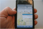
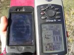
Using a Smartphone and ArcGIS Online to Teach Accuracy, Precision, GPS, and Critical Thinking
Now that it is easy to gather tracks and waypoints on a smartphone and map them in a GIS, it provides a good opportunity to remind students about the importance […]
Thinking Spatially with GIS
What would you do in 75 minutes to introduce your colleagues to spatial thinking and analysis? Recently I had the opportunity to do just that, when my Esri colleague Laura […]
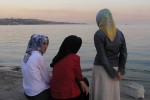 At the Sea of Marmara, Istanbul, Turkey
 Bicycling in Bavaria, Germany
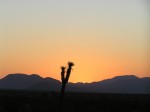 Joshua Tree at Sunrise, Mojave Desert
 Sunset on the San Diego Bay
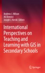 International Perspectives on Teaching and Learning with GIS in Secondary Schools
International Perspectives on GIS in Secondary Schools Publication Date: January 2012 | ISBN-13: ISBN 978-94-007-2119-7 . Is the first book to capture an international perspective on the status of GIS […]
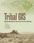 Tribal GIS: Supporting Native American Decision Making
Tribal GIS: Supporting Native American Decision Making Publication Date: June 16, 2012 | ISBN-10: 1589483200 | ISBN-13: 978-1589483200 In Tribal GIS: Supporting Native American Decision Making, tribal leaders tell their […]
New Book: The GIS Guide to Public Domain Data
A recurring topic in conferences, workshops, blogs, forums, listservs, and around the water cooler over the past 25 years is about spatial data–where to find it, how to use it, […]
Video: Geography Matters
In this 3 minute video, I make the case that Geography Matters–to education and to society. What part of sustainable development, energy, water, natural hazards, population, climate, or biodiversity is […]
Fieldwork at Gilman Historical Ranch, San Andreas Fault, California
Fieldwork at Gilman Ranch
 The Implementation and Effectiveness of GIS in Secondary Education: Geographic Information Systems in Education
Publication Date: July 22, 2009 Some educators consider GIS to be one of the most promising means for implementing educational reform. However, GIS technology has been adopted by only 1% […]
 Two chapters in Digital Geography: “Geospatial Technologies in the Social Studies Classroom”
Publication Date: February 12, 2008 | ISBN-10: 1593116721 | ISBN-13: 978-1593116729 A volume in International Social Studies Forum: The Series Series Editors Richard Diem, University of Texas at San Antonio […]
 The Handbook of Geographic Information Science
Chapter entitled “Geographic Information in Education” August 2007 ISBN: 978-1-4051-0796-9 John Wilson and A. Stewart Fotheringham, Editors This Handbookis an essential reference and a guide to the rapidly expanding field […]
 The Essentials of the Environment
Publication Date: February 16, 2006 | ISBN-10: 0340816325 | ISBN-13: 978-0340816325 Environmental issues such as possible climate change, pollution, nuclear waste, water resources, food and famine have a high public […]
 “Using GIS to Transform the Mathematical Landscape”
A math-based chapter written with Dr. Bob Coulter in “Technology-Supported Mathematics Learning Environments 67th Yearbook” (2005) By William Masalski, Portia Elliott. Edited by William J. Masalski Technology is playing an […]
 Foreword in “Making Community Connections: The Orton Family Foundation Community Mapping Program”
Publication Date: July 1, 2003 Making Community Connections calls for a more integrative look at the world we live in. Invariably, the Community Mapping Program makes more clearly visible the […]